Google AlphaEarth uses observation data for global mapping
Google AlphaEarth creates global maps from diverse observation data, to track environmental changes, improve disaster response, & enhance decision-making.
Introduced on July 30, 2025, AlphaEarth Foundations is a geospatial foundation model developed by Google DeepMind. It’s one of the highlights in recent Google AI news, and is built to make working with global Earth observation data faster, clearer, and more reliable.
AlphaEarth Foundations is trained on billions of data points from satellite imagery, radar, LiDAR (Light Detection and Ranging), elevation models, and climate simulations. Using this wide range of inputs, it creates yearly, 10-meter resolution views of the planet.
Simply put, this means it can produce clear, consistent maps of Earth’s surface, even in hard-to-see areas, so changes in land, water, and climate are easier to spot and track over time. These snapshots are now available through Google Earth Engine, Google’s cloud platform for geospatial data.
In this article, we’ll take a look at how AlphaEarth Foundations uses AI for Google Earth Engine to support real-world Earth observation projects.
Link to this sectionAlphaEarth: Google’s new AI model for Earth observation#
AlphaEarth Foundations provides a new way to understand our planet through a continuous and dynamic system. Instead of viewing each image separately, the new AI model builds a unified, structured picture of Earth’s surface across both space and time.
To create this view, it draws from a wide range of sources, including satellite images, elevation maps, climate models, and reports on biodiversity. This helps it pick up on changes in the environment and analyze the reason behind them.
In particular, AlphaEarth can showcase how Earth’s landscapes are changing over the years. These snapshots are built using embeddings, which are compact summaries of what the model has learned about each location.
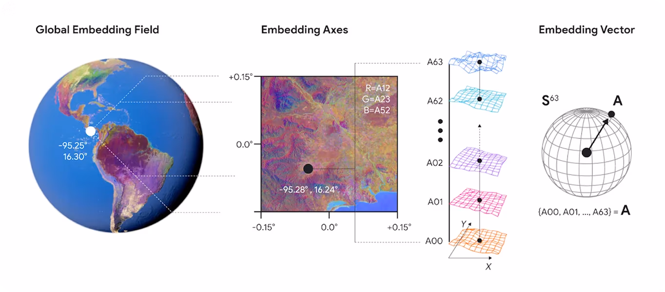
Fig 1. Google’s AI model uses numerical embeddings to map Earth’s surface. (Source)
A collection of these embeddings is available via Google Earth Engine’s Satellite Embedding dataset. They’re already being used in areas like wildfire response, urban planning, and land monitoring. This helps researchers and decision-makers turn satellite data into useful insights.
Link to this sectionAI and the climate: The significance of AlphaEarth#
A key benefit of AlphaEarth Foundations is that it makes studying long-term changes to our planet easier. It works well even in tricky areas where data is missing or clouds often block satellite views. For example, in the Amazon rainforest, where cloud cover is a constant issue, AlphaEarth can still spot land changes by learning from patterns around the world.
In benchmark tests, it reduced misclassification errors by nearly 24% and required 16 times less storage per embedding. Interestingly, this new AI model doesn't need to be retrained for every application.
It is efficient and adaptable across different regions and challenges. This is because AlphaEarth produces general-purpose embeddings, compact, information-rich summaries of each location, that can be used directly for many types of analysis without rebuilding the entire model.
So far, the new Google Earth AI model has been used to monitor land changes across more than 100 countries, including tropical forests, Arctic regions, and expanding cities. These insights are being used to support smarter planning and more informed climate decisions.
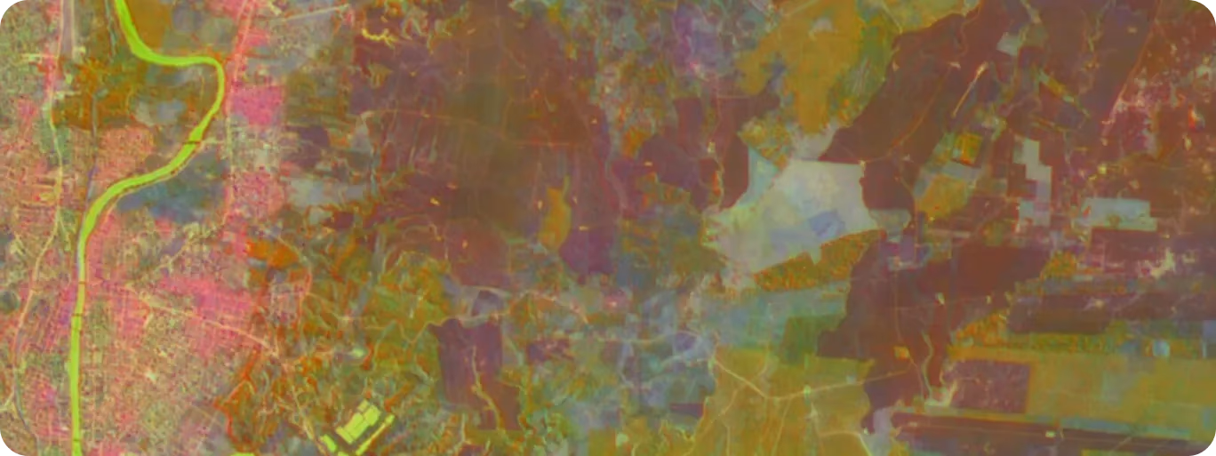
Fig 2. Visualizing global patterns with Google’s new AI model. (Source)
Link to this sectionHow AlphaEarth uses computer vision for Earth observation#
While satellite images can be used to capture detailed views of Earth’s surface, turning those images into meaningful insights is not always straightforward. AlphaEarth Foundations uses computer vision, a branch of AI that enables machines to interpret visual information, to detect and analyze patterns across land, vegetation, and terrain.
Here’s how the model applies different computer vision tasks to Earth observation:
- Image classification: AlphaEarth identifies land types such as forests, croplands, wetlands, and urban areas from satellite imagery. These classifications support climate monitoring, ecological research, and land-use planning.
- Segmentation: Also called thematic mapping, segmentation labels each pixel in a satellite image with a category like crop type or vegetation cover. AlphaEarth uses its annual embeddings to maintain high accuracy across regions, enabling fine-grained mapping for land use, land cover, and biodiversity.
- Change detection: By comparing annual embeddings for the same location, AlphaEarth can detect shifts in land use and land cover, such as deforestation, wildfire impacts, or urban growth. It works with both supervised methods (learning from labeled examples) and unsupervised methods (finding patterns without labels).
- Unsupervised clustering: Without using any labeled data, AlphaEarth can group regions that show similar patterns in satellite images. This helps detect trends like vegetation shifts or climate anomalies in new or understudied areas. It's especially impactful when labeled data is limited or missing.
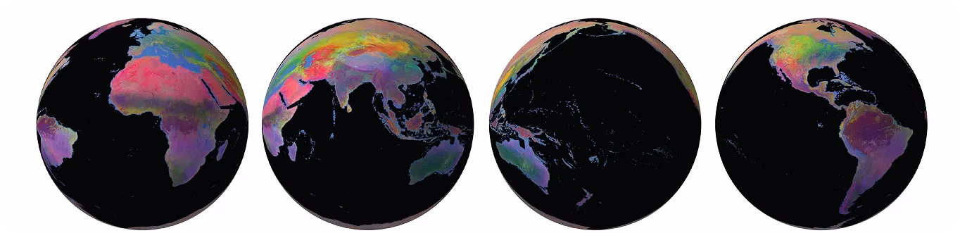
Fig 3. A look at using AI for Google’s latest innovation, AlphaEarth, to understand Earth’s environment in 2023. (Source)
Link to this sectionReal-world applications of Google’s new AI model#
With a better understanding of how AI for Google’s new Earth observation technologies work, let’s explore AlphaEarth Foundations' real-world applications.
Link to this sectionGoogle Earth’s AI initiative for greener US cities#
Across the US, cities are growing urban forests to reduce heat, absorb pollution, and boost public health. But pinpointing exactly where trees are, and where they aren’t, can be challenging. In dense neighborhoods and narrow streets, greenery often goes undetected in satellite images or traditional surveys.
However, AlphaEarth uses satellite, elevation, and environmental data to map tree cover with fine detail. To test this new AI Google model, researchers used over 45,000 tree records from iNaturalist.
They focused on 39 common tree genera (groups of closely related species) found across all US states, including Alaska and Hawaii. The data was cleaned and split into training and test sets, with 300 samples per genus used for training and the rest for testing.
The model accurately mapped tree cover from satellite, elevation, and environmental data, showing it can fill gaps left by traditional surveys. These insights can help cities like Detroit, New York, and Phoenix make better decisions about where to plant trees, cool neighborhoods, and support local biodiversity.
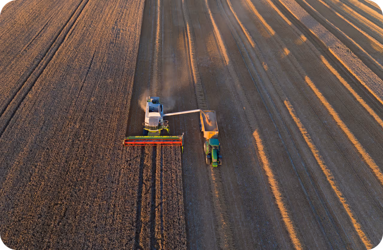
Link to this sectionSmarter crop mapping powered by Earth observation satellites#
Canada’s crop inventory depends heavily on field-level observations, especially in areas without crop insurance records (official reports of crop type, location, and acreage collected for agricultural insurance programs). These windshield surveys, often done from moving vehicles, are used to track major crops such as cereals, oilseeds, fruits, and forages.
But since some crop types are recorded more frequently than others, the data can be uneven and difficult to convert into reliable, large-scale maps. To work around these issues, AlphaEarth can support both high-level and fine-grained crop classification based on data from Earth observation satellites.
It can group crops into broad categories like grains or oilseeds. In regions where detailed survey data is available, it can also identify specific types such as spring wheat, corn, or alfalfa. This two-level approach balances coverage with detail, offering a clearer picture of what’s growing across Canada.
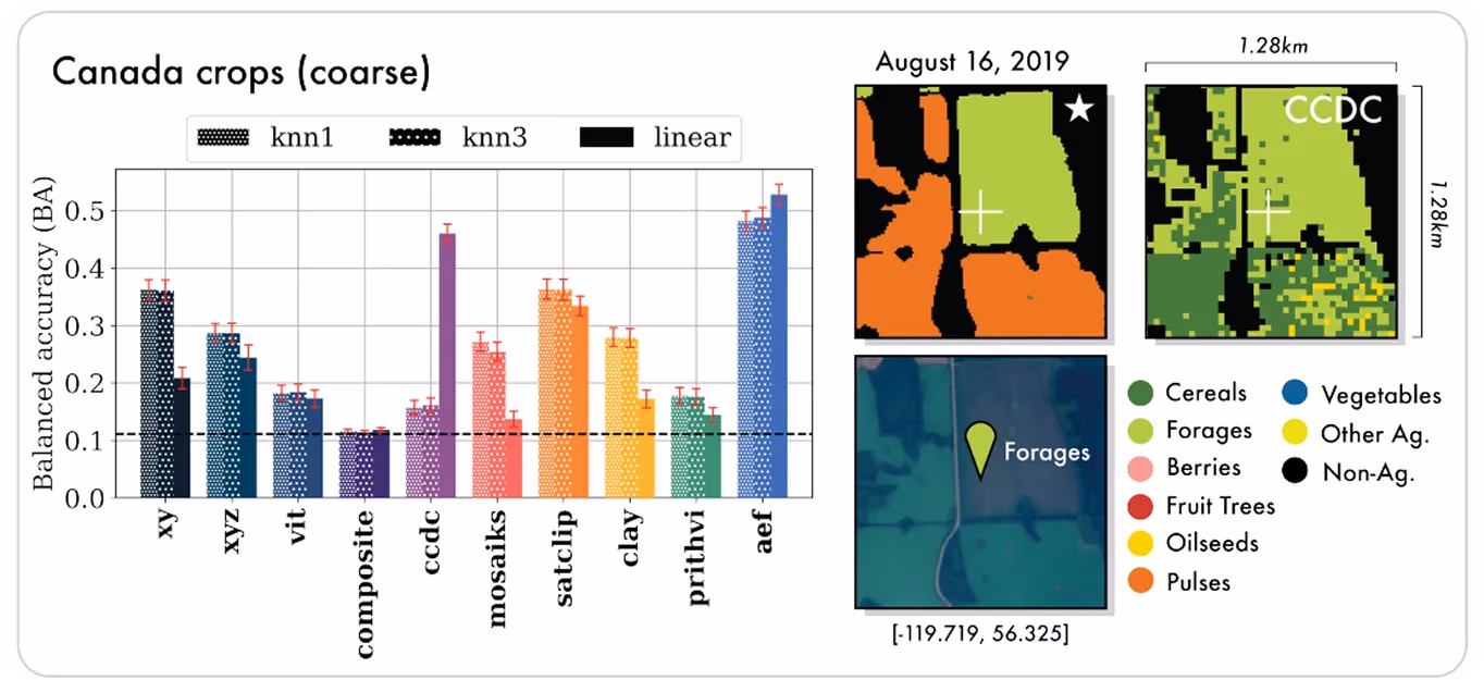
Fig 4. Google AlphaEarth helps classify crops in Canada. (Source)
Link to this sectionExploring global terrains with AI for Google Earth technology#
Antarctica is one of the hardest places on Earth to map, with extreme weather, constant snow cover, and limited satellite visibility. This leaves gaps in our understanding of its glaciers, exposed rock, and how the landscape is changing over time.
By combining satellite images with radar and elevation data, AlphaEarth produces consistent yearly maps of Antarctica, even in areas with limited visibility. It can fill in missing details and generate 10-meter resolution terrain maps that help researchers track glaciers, surface textures, and snow-covered land more accurately.
Link to this sectionPros and cons of the new AI model: AlphaEarth#
Here are some of the key advantages the new AI model, AlphaEarth Foundations, offers for Earth observation and urban planning applications:
- Versatility: AlphaEarth can be used in multiple fields like agriculture, urban planning, and disaster response without the need for separate models.
- Fills data gaps: This new AI Google model can create yearly summaries even when satellite input is incomplete, helping maintain continuity in time-series analysis.
- AI-ready outputs: It produces embeddings that can feed directly into tools like crop monitors, flood detectors, or land-use classifiers, saving time for researchers and developers.
While AlphaEarth offers reliable support across various domains, here are a few limitations to keep in mind:
- Not real-time: Annual embeddings from AlphaEarth are not suitable for applications requiring daily or near-real-time monitoring.
- Depends on input quality: While it fills gaps, the model still relies on the quality and availability of satellite, radar, and other input data sources.
- Limited interpretability: As with most deep learning models, it can be difficult to interpret exactly how AlphaEarth arrives at certain patterns or predictions.
Link to this sectionKey takeaways#
AlphaEarth Foundation is helping researchers, planners, and policymakers see the planet in new ways. Google’s new AI model can turn raw satellite inputs into structured, reliable information that supports better decisions in areas like climate science, agriculture, and urban development. By advancing Earth observation, it’s making it easier to monitor and understand our planet’s changes over time.
Join our community and explore AI innovations on our GitHub repository. Learn about AI in agriculture and computer vision in healthcare through our solutions pages. Check out our licensing plans and get started with AI today!