The role of computer vision in city maintenance tasks
See how computer vision in city maintenance can automate infrastructure monitoring, sewage inspection, road repairs, and urban planning for smarter, safer cities.

There’s a lot of work that goes into maintaining a city, but most of these tasks go unnoticed. For example, at night, maintenance teams work on repairing roads, clearing waste, checking lights, and ensuring the city stays safe and functional.
Worn-out roads, blocked drains, and broken streetlights might initially seem minor. But if left unchecked, they can quickly turn into larger problems. These routine maintenance tasks are important for public safety. However, with growing populations and limited municipal staff, traditional maintenance methods can struggle to keep up.
Computer vision, a branch of AI that focuses on processing and understanding visual data, offers a faster, more efficient approach to everyday maintenance in smart cities. By analyzing video feeds or aerial images, Vision AI solutions can automatically detect and track issues, reducing the burden on manual teams.
By using advanced computer vision models like Ultralytics YOLO11, cities can easily perform tasks such as identifying waste, potholes, or fallen branches. Vision AI tasks, like object detection and instance segmentation, can help maintenance teams respond quickly and keep public spaces neat, clean, and safe.
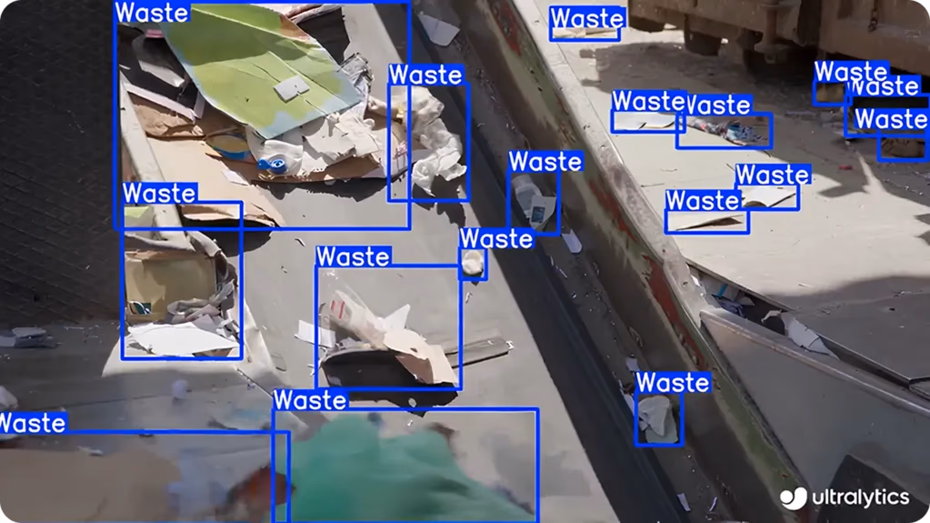
Fig 1. Detecting waste using YOLO11’s object detection capabilities. (Source)
In this article, we’ll explore how computer vision supports urban maintenance, some common applications, and the benefits it offers. Let's get started!
Link to this sectionAn overview of computer vision in city maintenance#
Urban authorities are using technologies like computer vision to better understand and manage city infrastructure. Visual data is collected through drones, cameras, and sensors, then processed using computer vision models like YOLO11 to get fast and accurate insights.
For instance, in smart cities, computer vision is being used to automatically detect graffiti through aerial images and street-level cameras, helping city teams clean it up quickly and keep public spaces welcoming.
Here’s a glimpse of some of the key computer vision tasks that enable smart city systems:
-
Object detection: Computer vision models like YOLO11 can identify and locate specific objects in an image or video feed. In urban maintenance, this helps teams detect items like traffic cones, trash bins, or broken street signs that may need attention.
-
Image classification: It assigns a label to an entire image based on its appearance. For instance, aerial shots of roads can be classified as clean, cracked, or flooded, helping teams sort and respond to different scenarios more efficiently.
-
Object tracking: Tracking is used to track moving objects across video frames to follow their paths. In cities, it helps monitor vehicles and pedestrians, improving traffic management and safety.
-
Instance segmentation: This technique separates individual instances of the same object. In city environments, it can be used to distinguish between multiple streetlights, trees, or parked vehicles for better tracking and upkeep.
Link to this sectionComputer vision in city maintenance applications#
Now that we have a better idea of how computer vision supports urban city maintenance, let’s explore some of its real-world applications.
Link to this sectionSmart infrastructure inspection with AI#
Maintaining underground drains is a challenging but essential job because damage can lead to serious health or environmental problems. Computer vision is now being used to make these inspections safer and more efficient. Drones with cameras, sensors, and Light Detection and Ranging (LiDAR) systems are used to check tunnels and collect real-time data on things like gas levels, temperature, and damage.
In Michigan, USA, Macomb County is a great example of how technology is improving underground inspections. After a pipeline collapse in 2016, the county started moving away from manual checks and began using automated systems.
Now, they use drones like the Elios 3 and Asio X to safely explore underground tunnels. The drones collect video and sensor data, which is then analyzed with computer vision to spot any structural issues. Since switching to this approach, the county has cut inspection costs by almost 40% and made the work much safer for their crews.
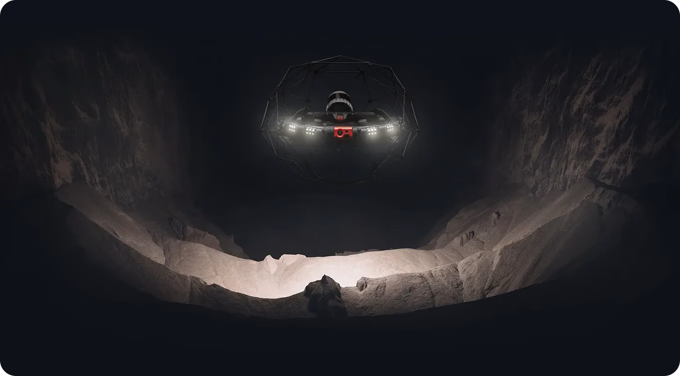
Fig 2. The Elios 3 drone can be used for sewage inspection. (Source)
Link to this sectionComputer vision for public road works#
Similarly, maintaining roads and managing traffic is a key part of keeping a city running smoothly. Roads can wear down over time due to heavy traffic and weather, leading to cracks, potholes, and damaged signs.
To tackle this, many cities are now using drones and vehicle-mounted cameras powered by computer vision to monitor road conditions and traffic in real-time. This technology helps spot problems early, improve safety, reduce congestion, and make repairs faster and more accurate.
That’s exactly why the city of Ahmedabad in India is outfitting municipal vehicles with AI-powered dashcams that scan roads in real-time. These cameras detect potholes, cracks, and surface wear, capturing images and geotagging the damage. The collected data is sent to a control center, where officials generate reports and heatmaps to prioritize repairs, helping speed up road maintenance.
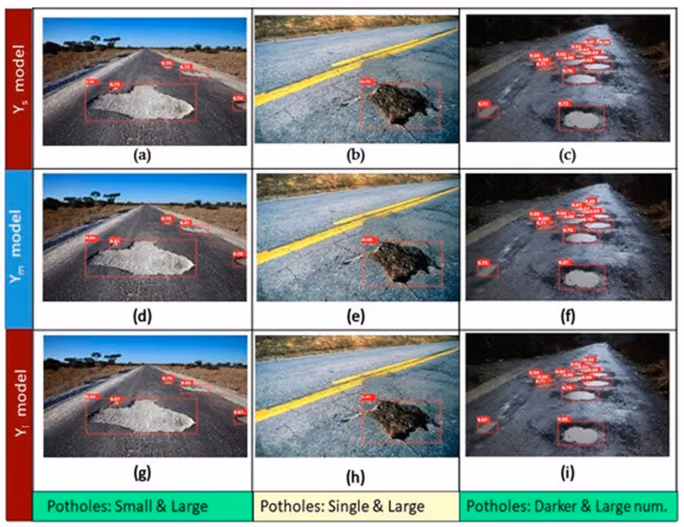
Fig 3. An example of pothole detection with size estimation using computer vision. (Source)
Link to this sectionMonitoring green spaces in cities with computer vision#
As the human population increases, cities expand, and as cities expand, green spaces shrink. Unfortunately, this can negatively impact air quality, temperature, and wildlife. Trees help absorb carbon gases, cool urban areas, and support biodiversity.
Focusing on going green, many cities are starting to use drones, vision models, LiDAR, and geographic information systems (GIS) to monitor green cover. These technologies help map tree locations, assess their health, and guide efforts for conservation, replanting, and development. This helps make green space management more accurate and essential for sustainable urban planning.
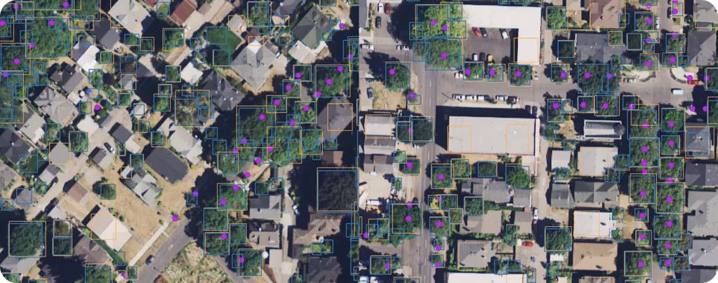
Fig 4. Identifying urban trees using high-resolution aerial data. (Source)
An interesting example is New Delhi, India, where the city has been struggling with air pollution. To address the problem, they launched a four-year tree census led by the Forest Research Institute.
Using drones, LiDAR, and GIS, they’re mapping and monitoring urban trees - tracking their species, health, and location. This use of technology is helping the city manage its green spaces more effectively, which can improve air quality and support India’s goal of reaching net-zero emissions by 2070.
Link to this sectionVision AI applications in urban planning and monitoring#
Illegal construction creates serious problems in cities. It can block roads, put pressure on public services, and interfere with planned development. An emerging approach to handling this uses computer vision to compare aerial images taken over time. This makes it possible to detect even small changes in buildings or land use early, allowing authorities to respond before the issue escalates.
For example, in Bavaria, Germany, researchers have developed methods that use AI and computer vision to analyze satellite images and geospatial maps in order to detect unauthorized buildings. They also relied on the Temporal Digital Surface Model (tDSM), which tracks changes in surface elevation over time.
By combining these tools, researchers can identify new constructions by monitoring elevation shifts and comparing images. This approach helps local authorities enforce building regulations more effectively, plan for sustainable development, and maintain accurate records.
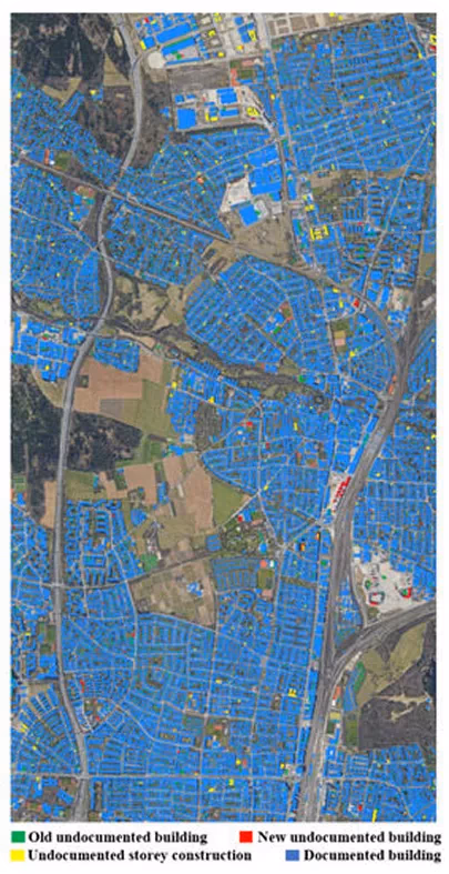
Fig 5. A map showing documented and undocumented buildings in the city. (Source)
Link to this sectionPros and cons of computer vision in city maintenance#
Here are some key benefits of using computer vision for smart city maintenance:
- Scalable coverage: Computer vision can monitor large urban areas using existing infrastructure like CCTV or drones, reducing the need for manual inspections.
- Dynamic resource use: Real-time analysis helps prioritize tasks based on urgency, making maintenance more efficient and cost-effective.
- Faster emergency alerts: AI-powered vision systems can detect incidents like fires, accidents, or flooding almost instantly, allowing for quicker response and reduced damage.
While computer vision systems provide reliable support for maintaining cities, they also come with certain limitations. Here are a few key factors to keep in mind when using these technologies:
- High initial costs: Deploying computer vision systems requires significant upfront investment in cameras, sensors, and AI infrastructure. Smaller municipalities may find it challenging to afford these expenses initially.
- Privacy concerns: Constant visual monitoring may raise concerns about surveillance and personal privacy among city residents.
- Infrastructure challenges: Older cities may lack the digital infrastructure needed for large-scale implementation (e.g., stable connectivity, power, or sensor networks).
Link to this sectionKey takeaways#
Smart cities are transforming urban life by using computer vision to maintain infrastructure better. With real-time monitoring and predictive insights, this technology helps cities respond to issues faster, use resources more efficiently, and keep residents safe. Increasingly, municipalities are shifting from reactive fixes to proactive, data-driven planning.
Looking ahead, AI and computer vision will likely play a bigger role in making cities greener, fairer, and more efficient. Tools like digital twins and generative AI complement these technologies by allowing planners to test new ideas, improve public services, and close gaps in access. Together, these innovations are helping shape urban environments that are not only smarter and safer but also more responsive to the needs of their communities.
Join our community and explore our GitHub repository to learn more about computer vision. Discover various applications related to AI in manufacturing and computer vision in healthcare on our solutions pages. Check out our licensing options to get started with Vision AI.