Redefining biodiversity surveillance with computer vision
Learn how computer vision enables biodiversity monitoring by detecting species, tracking habitat change, and supporting modern global conservation efforts.
Earth is home to an incredible range of life, from microscopic organisms to forests and wildlife, all connected through shared ecosystems. This diversity of life, known as biodiversity, supports essential systems such as clean water, fertile soil, food production, and the ecological balance that enables both people and wildlife to thrive.
However, that balance is shifting. Anthropogenic pressures or human-driven environmental impacts like deforestation, expanding cities, land use change, and climate change are reshaping habitats and placing many species at risk.
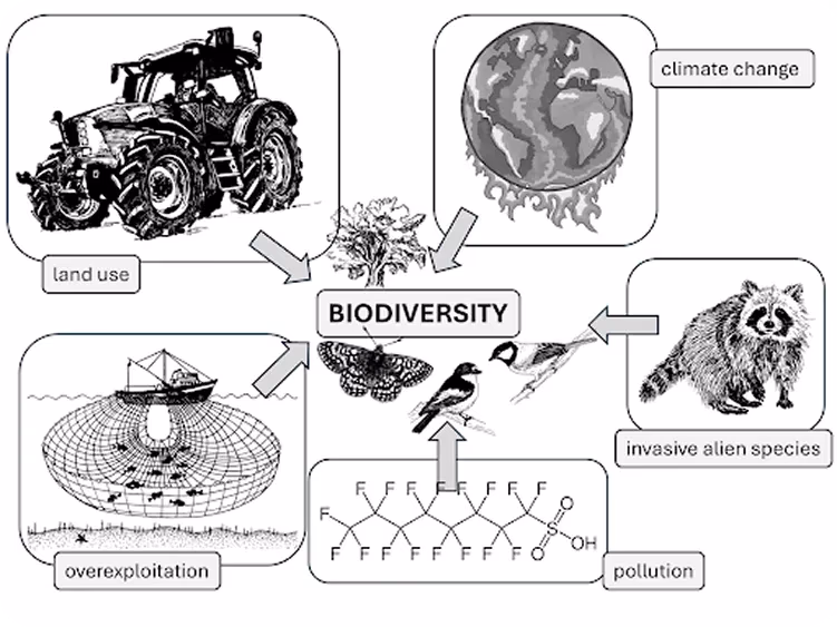
Fig 1. A look at factors affecting biodiversity (Source)
To better understand these changes, scientists and environmental researchers rely on continuous monitoring systems to track biodiversity over time and identify which ecosystems are under stress and which are recovering. By collecting consistent data across regions and seasons, they can detect patterns, measure ecosystem health, and respond more quickly to emerging threats.
These insights inform conservation planning, policy decisions, and long-term sustainability efforts. Traditional monitoring methods, however, are often slow, expensive, and difficult to carry out across large or remote areas.
That’s why computer vision, a branch of artificial intelligence (AI), is becoming an important tool in biodiversity surveillance. By analyzing images and videos from camera traps, drones, and satellites, computer vision systems can automatically detect species, track movement, and identify habitat changes in near real time.
In this article, we’ll explore what biodiversity means, how biodiversity surveillance works, and how computer vision supports modern conservation efforts. Let's get started!
Link to this sectionWhat is biodiversity?#
Biodiversity, also known as biological diversity, refers to the variety of life and species richness on Earth. It includes plants, animals, microorganisms, and the ecosystems they form, along with the genetic differences that exist within species.
This diversity exists at multiple levels, from variations in genes within a single species to the wide range of species and ecosystems across the planet. Each level highlights how life is interconnected and how natural systems function together.
Understanding these layers helps us see how ecosystems remain balanced and resilient. Biodiversity plays a critical role in maintaining ecosystem health and stability.
Ecosystems with higher biodiversity are generally better equipped to withstand climate change, disease outbreaks, and natural disturbances. In turn, they support essential services such as clean air, fresh water, fertile soil, climate regulation, and food production, which sustain both human societies and wildlife.
Link to this sectionVarious levels of biodiversity#
Our planet’s biodiversity is under growing threat from habitat loss, pollution, climate change, and overuse of natural resources. Understanding and monitoring biodiversity is the first step toward protecting it for future generations.
Here’s a look at the main levels of biodiversity and how each one contributes to balancing ecosystems:
- Genetic diversity: Differences in genes within a species enable organisms to adapt to changing environments, resist disease, and improve their chances of long-term survival.
- Species diversity: A wide variety of species living within the same ecosystem increases stability and reduces vulnerability to sudden environmental stress.
- Ecosystem diversity: Different environments, such as forests, wetlands, oceans, grasslands, and freshwater systems, support distinct communities of organisms and ecological processes.
- Functional diversity: The various roles organisms perform, including pollination, nutrient recycling, and decomposition, help maintain balance and ensure ecosystems operate effectively.
- Phylogenetic diversity: Evolutionary differences among species reflect the long history of life on Earth and highlight the complexity of biological relationships.
Link to this sectionUnderstanding biodiversity surveillance and why it matters#
Human-driven pressures such as deforestation, pollution, urban expansion, and land use change are influencing ecosystems across the globe. Many of these changes occur gradually, which can make them difficult to detect without consistent observation. That’s why long-term monitoring initiatives are more effective than relying only on occasional surveys.
Biodiversity surveillance provides a structured approach to this ongoing observation. It involves collecting and analyzing data over time to understand how species, habitats, and ecosystem conditions are changing.
Tools such as camera traps, satellites, drones, and environmental sensors help monitor different environments across regions. Repeated measurements in the same locations make it easier to identify trends and assess ecosystem stability.
This process relies on biodiversity indicators and metrics, including species counts, vegetation cover, habitat size, and the presence or absence of certain species. Over time, these indicators reveal patterns and act as early warning signs of ecosystem stress or recovery.
To keep monitoring consistent across regions, global organizations such as IPBES and IUCN provide shared standards and guidance. Their frameworks help ensure biodiversity data is reliable and useful for real conservation action.
Link to this sectionChallenges with traditional biodiversity monitoring methods#
Now that we’ve seen why continuous monitoring is important, let’s understand where traditional methodologies struggle. Here are some common challenges researchers and conservation teams face when using traditional monitoring methods:
- Slow manual work: Field surveys rely on people observing and recording species. This makes it harder to collect data consistently, especially for fast-moving or hidden animals in dense environments.
- Hard-to-reach areas: Mountains, oceans, rainforests, and remote regions are difficult and sometimes risky to access. Because of this, monitoring rarely happens on a large scale, leaving many ecosystems unchecked.
- Data gaps: Traditional approaches often result in uneven data collection, making long-term trends harder to understand.
- High costs: Fieldwork requires trained teams, travel, and equipment. These efforts are often not cost-effective, especially in regions with limited resources.
- Complex species tracking: Insects, birds, reptiles, and nocturnal animals can be difficult to monitor because they are small, seasonal, or active at night.
- No real-time insights: Without live updates, early warning signs are easy to miss, which delays action when ecosystems are under threat.
Link to this sectionThe role of computer vision in biodiversity surveillance#
Next, let’s explore how computer vision can enhance biodiversity monitoring. Most monitoring approaches today rely on a mix of tools deployed across natural environments.
For instance, camera traps watch forests, drones scan wetlands, and satellites track land changes through remote sensing. Underwater cameras observe marine life, while small sensors measure temperature, sound, and movement. Together, these tools form modern monitoring systems that continuously gather visual and environmental data.
Computer vision is a great option for this type of setup because it operates directly on images and videos. Instead of manually reviewing thousands of photos, vision systems can automatically scan datasets and highlight what matters.
When combined with sensor inputs such as motion, heat, or sound, this produces a clearer, real-time picture of what is occurring across habitats. In particular, vision AI models such as Ultralytics YOLO26 support key computer vision tasks like object detection, instance segmentation, and image classification, enabling teams to spot species, track movement, and detect habitat changes efficiently. This allows monitoring to scale across large or remote regions while reducing manual effort.
Link to this sectionKey computer vision tasks used for biodiversity surveillance#
Computer vision can make spotting and understanding wildlife much easier. It can be used to detect animals, birds, insects, and marine life in images and videos, track their movements, and reveal migration routes or behavior patterns.
It can also be used to segment and classify plants, animals, and landscapes in detail, helping monitor forests, coral reefs, water bodies, and other habitats. At the same time, it can quickly identify species from large sets of camera trap or drone photos, cutting down on tedious manual work.
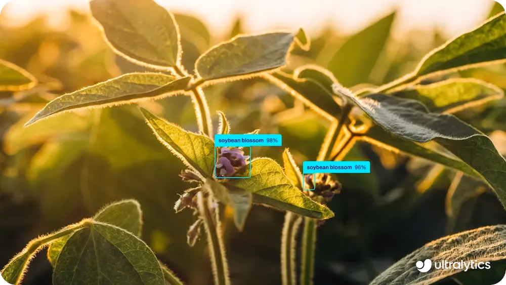
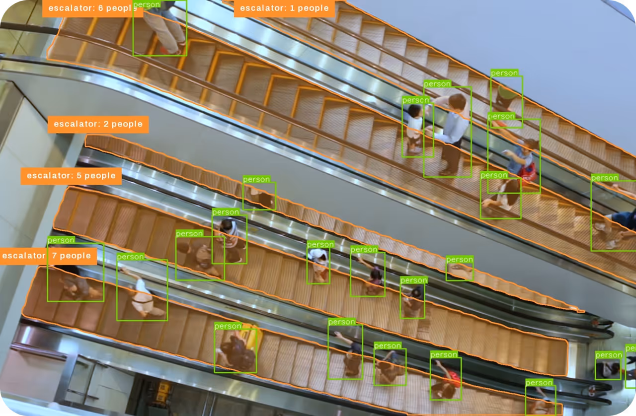
Fig 2. An example of detecting objects using Ultralytics YOLO26 (Source)
Together, these tasks generate actionable outputs, giving conservation teams near-real-time insights to detect changes, respond quickly, and scale monitoring across even the most remote areas.
Link to this sectionTurning data into action: Building vision AI for conservation#
Building a vision AI system starts with setting clear priorities, like tracking endangered species, monitoring threatened populations, or keeping an eye on fragile habitats in forests, oceans, and wetlands. Clear goals make it easier to choose the right tools and data.
Data is then collected using camera traps, drones, and satellites, capturing images and videos from all kinds of environments, including remote or hard-to-reach areas. This means wildlife and habitats can be observed more frequently and with minimal disturbance.
The data is then cleaned and labeled to ensure the system can accurately distinguish among animals, plants, and landscapes. Models such as YOLO26 are trained to recognize species, track movement, and detect habitat changes, and they are tested across different weather, lighting, and background conditions to ensure consistent performance in real-world environments.
Once deployed, these models can operate continuously, analyzing incoming images and video streams to deliver timely, actionable insights that support conservation biology, improve ecosystem management strategies, and enable faster responses to environmental change.
Link to this sectionVision AI applications powering biodiversity surveillance#
Next, let’s walk through some real-world applications that show how computer vision is being used to support biodiversity monitoring and conservation.
Link to this sectionAutomating wildlife monitoring with computer vision#
Wildlife monitoring is especially important in protected areas, where many endangered and threatened species rely on stable habitats. Camera traps are widely used to observe animals over large and remote areas while keeping human disturbance to a minimum.
Reviewing the sheer volume of collected images manually, however, is time-consuming and makes it difficult to fully utilize the data collected for tasks like species identification. Computer vision models like YOLO26 help solve this problem by automatically detecting animals in camera trap images.
This reduces manual effort and improves consistency, making it easier to monitor wildlife at scale. Thanks to vision-driven automation in monitoring, biodiversity conservation efforts are strengthened through tracking endangered species, monitoring mammals, vertebrates, reptiles, birds, and pollinators, and analyzing population changes over time.
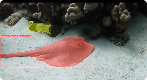
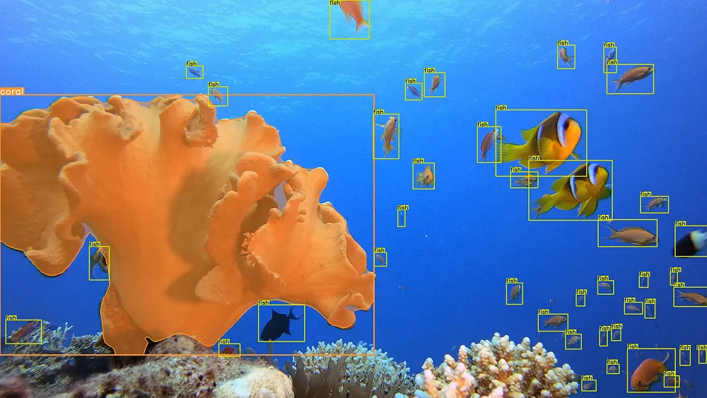
Fig 3. Using YOLO26 to detect and segment wildlife in underwater environments
These systems also support habitat assessment by identifying areas that are becoming more or less suitable as environmental conditions change. Overall, computer vision enables continuous, scalable wildlife monitoring that is faster and more reliable, while making maintenance simpler.
Link to this sectionFreshwater ecosystem monitoring#
Freshwater and coastal ecosystems are constantly changing, and invasive species can spread unnoticed until they cause serious damage. Early underwater detection is challenging because of poor visibility, uneven lighting, and cluttered scenes. Vision AI helps by continuously analyzing images and videos, making it easier to catch warning signs before problems escalate.
For example, researchers have used an Ultralytics YOLOv8-based system, one of the earlier iterations leading to models such as YOLO26, to detect invasive sun corals (Tubastraea species), bright-colored corals that grow quickly and outcompete native reef species. These corals can alter local ecosystems by crowding out native corals, reducing biodiversity, and changing habitat structure.
The model was trained to handle challenges such as blur, low light, and underwater distortion, accurately identifying both open and closed coral forms and enabling teams to detect new growth at an early stage. Vision-powered continuous underwater monitoring lets teams focus on areas that support suitable habitats for native species and manage threats more effectively, rather than relying only on occasional manual surveys.
Link to this sectionTracking ecosystem health and biodiversity indicators#
Keeping ecosystems healthy means detecting changes early. Traditional methods like field surveys or occasional satellite checks are slow and often miss early warning signs, leading to biodiversity loss, climate impacts, and harmful human activity continuing until serious damage occurs.
Continuous monitoring offers a clearer and more consistent way to track biodiversity and ecosystem services over time. Vision AI makes this process more efficient by automatically analyzing large volumes of images and identifying meaningful changes.
In a recent study, a system integrated with YOLOv8, machine learning, and agentic AI (which can analyze data and make decisions independently) was used to monitor deforestation in real time. It detected tree cutting, forest clearing, and logging activity in satellite and drone images, while also tracking land-use changes and shifts in vegetation patterns. By automating these tasks, conservation teams can get timely insights and act faster to protect ecosystems before problems escalate.
Link to this sectionDetecting invasive plants in farmland and natural areas#
Invasive weeds can spread fast across farms and nearby natural areas, pushing out native plants and disrupting local ecosystems. They steal water, nutrients, and sunlight, which weakens plant diversity and soil health.
Since they often look like crops, spotting them by eye can be time-consuming, and by the time you do, they’ve usually already spread. With computer vision, finding these weed hotspots becomes quick and reliable.
For instance, YOLO26 can be used to analyze field images and pick out weeds at different growth stages, separating them from crops with ease. Catching weeds early gives farmers and land managers a big advantage. They can treat only problem spots, reduce chemical use, protect nearby plants, and keep the soil healthy over the long term.
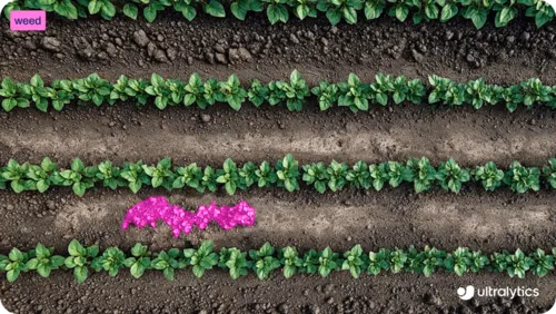
Fig 4. Segmenting invasive weeds in field environments using YOLO26 (Source)
Link to this sectionPros and cons of using vision AI for biodiversity monitoring#
Here are some of the main advantages of using vision AI for effective biodiversity monitoring:
- Consistent data collection: Vision AI systems apply the same detection logic across different locations and time periods, reducing human bias and making biodiversity data more standardized and comparable.
- Long-term trend analysis: By storing and processing large volumes of image and video data, these systems make it easier to analyze seasonal patterns, population shifts, and long-term ecological changes.
- Supports conservation planning: Automated insights support evidence-based conservation strategies, policy development, and environmental impact assessments, helping stakeholders with decision-making.
While vision AI offers clear benefits, here are some limitations to keep in mind:
- High setup cost: Deploying camera traps, drones, sensors, data storage, and computing infrastructure can require significant upfront investment, especially for large-scale monitoring programs.
- Limited model generalization: Models trained in one region or ecosystem may not perform equally well in new environments without additional retraining and fine-tuning.
- Data bias risks: If training datasets are unbalanced, rare species or underrepresented habitats may be detected less accurately, potentially skewing monitoring results.
Link to this sectionKey takeaways#
Biodiversity surveillance is transforming how we monitor ecosystems, replacing slow, manual surveys with continuous, AI-powered insights. By automating species detection and tracking habitat change, computer vision strengthens management strategies and enables faster, more informed responses to environmental threats. As these technologies continue to evolve, they will likely play a vital role in protecting ecosystems and advancing long-term sustainability.
Join our growing community! Explore our GitHub repository to learn more about AI. Discover computer vision in manufacturing and AI in logistics by visiting our solution pages. To start building with computer vision, check out our licensing options.